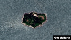
남북간 관할권 논란이 빚어진 함박도가 서해 북방한계선(NLL) 남쪽에 있다고 밝힌 빈센트 브룩스 전 유엔군사령관이 자신의 착오였다는 공식 입장을 VOA에 보내왔습니다. 당초 북한이 주장하는 해상경계선과 NLL사이에 사이에 낀 섬이라고 지적 했었지만 유엔사의 상반된 입장이 나온 뒤 ‘잘못된 발언’이었다며 이를 번복했습니다. 하지만 함박도의 무장화에 대한 우려는 여전하고 ‘위치 논란’ 역시 수그러들지 않고 있습니다. 김동현 기자가 취재했습니다.
한미연합사령관 겸 유엔군 사령관을 지낸 빈센트 브룩스 전 예비역 육군 대장은 18일 VOA와의 전화 인터뷰에서 함박도의 위치를 서해 북방한계선 (NLL) 이남으로 규정하면서 “북한이 주장하는 서해 해상경계선 사이에 낀 상태”라고 언급했습니다.
[녹취: 빈센트 브룩스 전 사령관] “You are right about it being South of NLL. But remember the NLL was not an armistice agreement measure. It was imposed by the UN commander just further separate the places where there could be unintended conflict and North Korea has its own control line and it's further South than Hambakdo so Hambakdo sits in between the two lines and that is why it is like that. So it means you address it differently”
그러나 하루 뒤 유엔군사령부가 NLL 북쪽이라는 입장을 내놓자, 브룩스 전 사령관은 VOA에 자신이 “잘못 기술했다(incorrectly stated)”며 입장을 바꿨습니다.
[녹취: 빈센트 브룩스 전 사령관] “So the statement was on the record so it was probably misengaged in my part but as UN Commander has reported Hambakdo is North of the Northern Limited Line so as I talked about North Korean controlled line being on the southern of the island is actually the islands are actually islands further to the west. Some of the other islands have some of those characteristics but Hambakdo was incorrectly stated. There is a problem of overlapping lines where islands are between the two lines and where North Korean line is further south than NLL, I think we had other island further to the west but Hambakdo it does not overlap”
인터뷰 당시 NLL 이남에 있다고 언급한 섬들은 사실 더 서쪽에 있는 섬들로, 북한의 서해 해상경계선이 NLL보다 남쪽에 있어서 두 선이 겹치는 구역에 섬들이 존재하는 문제가 있지만, 함박도는 겹치지 않는다”며 기존 발언을 번복했습니다.
그러면서도 앞서 인터뷰에서 밝힌 함박도의 잠재적 위협에 대한 입장은 여전하다고 밝혔습니다. 함박도가 NLL 북쪽에 있다하더라도 그 위치에서 위협을 가한다는 설명입니다.
[녹취: 빈센트 브룩스 전 사령관] “Yeah even in the North of the Northern Limited Line it creates a threat in the position there but it is actually a North Korean controlled area”
한미연합사령부 작전참모를 지낸 데이비드 맥스웰 민주주의수호재단 선임연구원은 20일 VOA와의 전화통화에서 “위치 논쟁을 떠나 중요한 것은 북한이 함박도를 점유한 사실이며, 향후 언제든지 무장화가 가능하다는 점이 매우 위협적”이라고 말했습니다.
[녹취: 데이비드 맥스웰 선임연구원] “While we can argue about who's right and who's wrong about who owns the island, the fact is, and this is the fact. North Korea has occupied that island. While we don't observe any offensive weapons visible on the island, that doesn't mean that there will be in the future. Or it could also mean it is not showing weapons such as guns, things that would fire kinetically. We should also be concerned with their electronic warfare capabilities that might be on the island that are not visible”
특히 운동에너지 기반 무기가 아니더라도 감지가 어려운 전자기반 무기체계로 무장할 경우, 군용 레이더 뿐 아니라 민간 항공기 운용에까지 직접적인 영향을 줄 수 있다고 경고했습니다.
[녹취: 데이비드 맥스웰 선임연구원] “Yes, the political problems are generated because of the ambiguity. And because of statements that are made various people, you know, including myself, and how they interpret this, we all have our different interpretations, in that causes, confusion and ambiguity and political problems. But we should keep focused on the fact that North Korea is occupying this island, and there is a potential threat to South Korea, and all the rest of the islands that may or may not be north or south of the NLL.”
NLL과 북한의 서해 해상경계선을 둘러싼 영역 문제는 모호함에서 발생하는 정치적 해석 문제지만, 북한이 함박도를 포함해 인근 섬을 점유하는 행위는 잠재적 위협이라는 설명입니다.
브루스 베넷 랜드연구소 선임연구원은 VOA에 함박도를 캐나다와 미국 국경의 나이아가라 폭포에 비교하며, “함박도 문제는 영유권을 정의할 수 있는 NLL 선언 당시 역사적 자료와 당국의 조정 부재에서 비롯됐다”고 지적했습니다.
[녹취: 브루스 베넷 선임연구원] “You could only do that with authorized parties has the ability to make the definition of that border which we are prepared to make that definition…You know I think what we do not have is a historical record what the definition of the NLL was”
브루스 베넷 랜드연구소 선임연구원은 VOA에 과거 대부분의 지도가 함박도를 NLL 이남으로 표시해왔다며, 함박도가 NLL 북쪽이라는 유엔군사령부의 첫 공식입장 표명에 놀랐다는 반응을 보였습니다.
[녹취: 브루스 베넷 선임연구원] “I assume that most of the maps were accurate in drawing that line. So I'm a little surprised by the change that seems to have occurred. But, you know, that is really, it's really a matter for the UN for me to go back to this historical records and demonstrate… It would be helpful if we could find the UN documents that define initially the NLL and identify whether or not the original designation”
베넷 선임연구원은 다만, 과거 지도들이 모두 첫 지정될 당시의 NLL을 바탕으로 제작됐다는 점에서, 유엔군 사령부는 역사적 근거가 될 관련 문서를 함께 공개하는 것이 좋을 것이라고 말했습니다.
VOA뉴스 김동현입니다.
| 독자 제보: VOA는 독자 여러분의 제보를 기다리고 있습니다. 기사화를 원하는 내용을 연락처와 함께 Koreanewsdesk@voanews.com 이메일로 보내주시면 뉴스 제작에 적극적으로 반영하겠습니다. 제공하신 정보는 취재를 위해서만 사용되며, 제보자의 신분은 철저히 보호됩니다. |